REQUEST A TOUR
In-PersonVirtual Tour

$ 31,000
Est. payment | /mo
40.06 Acres Lot
$ 31,000
Est. payment | /mo
40.06 Acres Lot
Key Details
Property Type Vacant Land
Listing Status Active
Purchase Type For Sale
Subdivision Nv
MLS Listing ID 240002258
Lot Size 40.060 Acres
Acres 40.06
Property Description
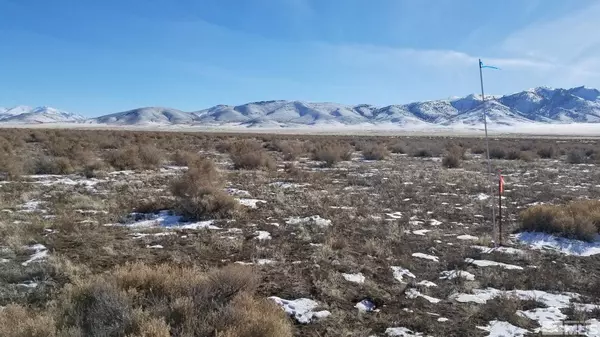
40.06+- acres raw land ready for development. Imagine your home, family, animals, landscape, views, and quietude, right here on 40+ acres. Beautiful, rural location, and easy to get to. Less than 2 miles driving to Interstate 80. This is a conveniently located property for your off-grid home, ranch, or recreational getaway. East Star Peak Road is a county road, recently resurfaced by the County. The land comes with a deeded driveway easement across the adjacent property to the north. 40 ACRES OPEN COUNTRY LAND 40.06+- acres raw land ready for development. Imagine your home, family, animals, landscape, views, and quietude, right here on 40+ acres. Beautiful, rural location, and easy to get to. Less than 2 miles driving to Interstate 80. This is a conveniently located property for your off-grid home, ranch, or recreational getaway. Zoned AMR (agriculture, mining, recreation), which allows a wide variety of potential uses including building a home. Located about 0.75 mi south of Interstate 80 as the crow flies, with easy access to both the Imlay interchange and the Mill City / NV Route 400 interchange. At the NV Route 400 junction with Interstate 80, there is a full service restaurant, market, and hardware store, an RV park, a TA truck stop with low priced fuel and various fast food options, and more. Mill City is located about 20 minutes west of Winnemucca, 2 hours east of Reno, and 4 hours west of Salt Lake City, all lying along Interstate 80. Off-grid location without utilities. If you want to build and need utiliy connections, solar is the most typical power source, water is typically obtained via private well, sewage disposal via private septic tank, and gas via propane delivery service, all at buyer's option and expense. Cell phone service appears to be normal in this location. East Star Peak Road is a county road, recently resurfaced by the County. The land comes with a deeded driveway easement across the adjacent property to the north. Property to be sold as-is, where-is. Buyer to conduct their own due diligence with regards to development possibilities, utilities, etc to ensure property meets Buyer's needs. Pershing County APN 008-270-21 Directions: Take Interstate 80 east from Reno. Exit at Imlay, which is exit 145. Upon exiting, go to the south side of the freeway, and turn left onto the frontage road. The road will turn from asphalt to gravel, and pass the Thunder Mountain Monument park. At the east end of the park, the road will fork. Take the left side of the fork. Continue another 500 feet, at which point the road will fork again. This time take the right side of the fork--this is E Star Peak Rd. Reset your odometer at this point and go straight for 0.7 miles, at which point the property will be on your right. All four property corners are marked with 10' tall white PVC pipes flying blue survey tape at the top (be advised grazing cattle sometimes knock these markers down, which makes them more difficult to find). See attached images and maps to assist you in identifying the property. There is no official street address yet for the property, so please type the GPS coordinates into Google Maps to locate the property; an official street address will be assigned by the County at the time of building. GPS 40.65420, -118.11535 (approximately the center of the property)
Location
State NV
County Pershing
Exterior
Utilities Available None
View Mountain, Yes, Desert
Topography Level,Gentle,Desert
Schools
Elementary Schools Imlay
Middle Schools Pershing
High Schools Pershing
Others
Tax ID 00827021
Horse Property Yes
Special Listing Condition None
Listed by Desert Acreage

Find out why customers are choosing LPT Realty to meet their real estate needs
Learn More About LPT Realty


